
Fayil:WW2-Holocaust-Europe-2007Borders.png
Hoton asali (pikisal 1,310 × 1,090, girman fayil: 597 KB, irin MIME: image/png)
Taƙaici
| Bayani |
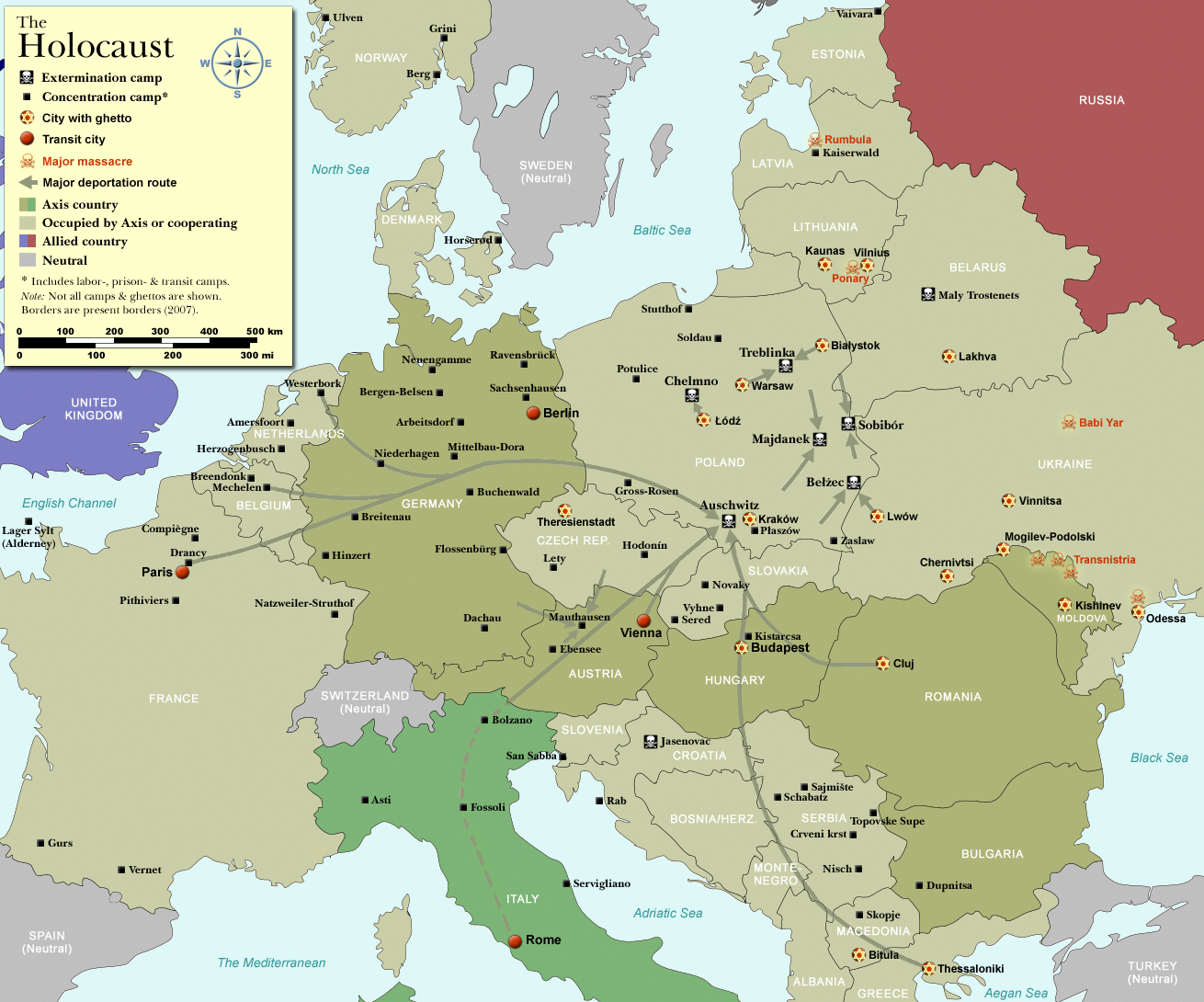
Map of the Holocaust in Europe during World War II, 1939-1945.
Übersetzung der "Notes" bis hierher: |
| Rana | |
| Masomi | Self-made by User:Dna-Dennis, using information from USHMM & Wikipedia. |
| Marubucin | User:Dna-Dennis |
| Izini (Sake amfani da wannan fayil) |
CC, see below. The map is completely unrestricted for any Wikipedia/Wikimedia project. |
| Other versions |
[]
|


.png)


.png)


|
This historical map image could be re-created using vector graphics as an SVG file. This has several advantages; see Commons:Media for cleanup for more information. If an SVG form of this image is available, please upload it and afterwards replace this template with
{{vector version available|new image name}}.
It is recommended to name the SVG file “WW2-Holocaust-Europe-2007Borders.svg”—then the template Vector version available (or Vva) does not need the new image name parameter. |
Lasisi
- Za ka iya:
- a raba – dan kwafa, yadawa da aika aikin
- dan maimaita – dan daukar aikin
- A karkashin wannan sharuddan
- Jinginarwa – Dole ku bada jinjina da ta dace, samar da linki zuwa lasisin, da kuma bayyana ko kunyi sauyi. Zaku iya haka ta yadda ta dace, amma ba kowace hanya ba wanda zai nuna mai-lasisin yana goyon bayan ku ba ko goyon bayan amfanin da kuke yi ba.
Tarihin fayil
Ku latsa rana/lokaci ku ga fayil yadda yake a wannan lokaci
| Rana/Lokaci | Wadar sufa | Kusurwowi | Ma'aikaci | Bahasi | |
|---|---|---|---|---|---|
| na yanzu | 18:49, 2 Nuwamba, 2009 | | 1,310 × 1,090 (597 KB) | Flying Saucer | Vaivara location corrected |
| 10:40, 17 Disamba 2007 |  | 1,310 × 1,090 (767 KB) | Dna-webmaster~commonswiki | == Summary == {{Information |Description=Map of the Holocaust in Europe during World War II, 1939-1945. <br> This map shows all extermination camps (or ''death camps''), most major concentration camps, labor camps, prison camps, ghettos, major deportation |
Amfani da fayil
Babu shafuka da suke amfani da fayil din nan.
Amfanin fayil a ko'ina
Wadannan sauran wikis suna amfani da fayil din anan
- Amfani a kan bn.wikipedia.org
- Amfani a kan cs.wikipedia.org
- Amfani a kan en.wikipedia.org
- Amfani a kan es.wikipedia.org
- Amfani a kan it.wikipedia.org
- Amfani a kan ko.wikipedia.org
- Amfani a kan nl.wikipedia.org
- Amfani a kan no.wikipedia.org
- Amfani a kan pt.wikipedia.org
- Amfani a kan th.wikipedia.org
- Amfani a kan tr.wikipedia.org
- Amfani a kan uk.wikipedia.org