
File:Worldmaphedo.jpg
Babu wata babbar saƙa.
Worldmaphedo.jpg (pikisal 700 × 437, girman fayil: 57 KB, irin MIME: image/jpeg)
Taƙaici
| Bayani |
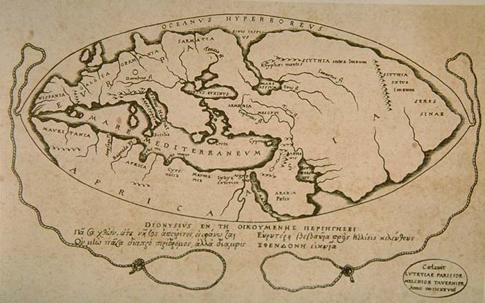
English: World map according to ideas by Posidonius (150-130 B.C.), drawn by 16th century cartographers Petrus Bertius & Melchior Tavernier in 1628. Many of the details in this map couldn't have been known by Posidonius, rather, Bertius and Tavernier show Posidonius' ideas about the positions of the continents. |
|||||||||||||||||||||||||||||||||||||||||||||
| Rana | ||||||||||||||||||||||||||||||||||||||||||||||
| Masomi | Armenica | |||||||||||||||||||||||||||||||||||||||||||||
| Marubucin |
|
|||||||||||||||||||||||||||||||||||||||||||||

Lasisi
|
This work is in the public domain in its country of origin and other countries and areas where the copyright term is the author's life plus 100 years or fewer. This work is in the public domain in the United States because it was published (or registered with the U.S. Copyright Office) before January 1, 1929. | |
| This file has been identified as being free of known restrictions under copyright law, including all related and neighboring rights. | |
Original upload log
Transferred from en.wikipedia to Commons by Woudloper using CommonsHelper.
The original description page was here. All following user names refer to en.wikipedia.
- 2007-02-08 14:26 Artaxiad 700×437×8 (57932 bytes) World map according to Posidonius (150-130 B.C.) {{GFDL-Armenica}}
Tarihin fayil
Ku latsa rana/lokaci ku ga fayil yadda yake a wannan lokaci
| Rana/Lokaci | Wadar sufa | Kusurwowi | Ma'aikaci | Bahasi | |
|---|---|---|---|---|---|
| na yanzu | 15:22, 20 Mayu 2008 | | 700 × 437 (57 KB) | Woudloper | {{Information |Description={{en|World map according to Posidonius (150-130 B.C.) Source: http://www.armenica.org/cgi-bin/history/en/getHistory.cgi?3=1==Historical%20maps==1=3=AAA}} |Source=Transferred from [http://en.wikipedia.org en.wikipedia]; transfer |
Amfani da fayil
Wadannan shafi na amfani wannan fayil:
Amfanin fayil a ko'ina
Wadannan sauran wikis suna amfani da fayil din anan
- Amfani a kan af.wikipedia.org
- Amfani a kan bn.wikipedia.org
- Amfani a kan bs.wikipedia.org
- Amfani a kan ca.wikipedia.org
- Amfani a kan cs.wikipedia.org
- Amfani a kan de.wikipedia.org
- Amfani a kan en.wikipedia.org
- Amfani a kan es.wikipedia.org
- Amfani a kan fa.wikipedia.org
- Amfani a kan fr.wikipedia.org
- Amfani a kan he.wikipedia.org
- Amfani a kan hi.wikibooks.org
- Amfani a kan hr.wikipedia.org
- Amfani a kan hy.wikipedia.org
- Amfani a kan it.wikipedia.org
- Amfani a kan ja.wikipedia.org
- Amfani a kan lv.wikipedia.org
- Amfani a kan nl.wikipedia.org
- Amfani a kan no.wikipedia.org
- Amfani a kan pnb.wikipedia.org
- Amfani a kan sh.wikipedia.org
- Amfani a kan sl.wikipedia.org
- Amfani a kan sr.wikipedia.org
- Amfani a kan th.wikipedia.org
- Amfani a kan uk.wikipedia.org
- Amfani a kan ur.wikipedia.org
- Amfani a kan zh.wikipedia.org