Jump to content

Fayil:A Delta Oasis in Southeastern Kazakhstan.jpg

Page contents not supported in other languages.
Daga Wikipedia, Insakulofidiya ta kyauta.

Hoton asali (pikisal 4,198 × 4,198, girman fayil: 7.55 MB, irin MIME: image/jpeg)

Wannan hoto yazo daga Wikimedia Commons kuma za'a iya amfani dashi a wasu projects. Anan kasa an nuna asalin bayanin shi

Taƙaici

Bayani

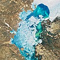
Seen from space, the Ili River Delta contrasts sharply with the beige deserts of southeastern Kazakhstan.

When the Operational Land Imager (OLI) on Landsat 8 acquired this natural-color image on March 7, 2020, the delta was just starting to shake off the chill of winter. While many of the delta’s lakes and ponds were still frozen, the ice on Lake Balkhash was breaking up, revealing swirls of sediment and the shallow, sandy bed of the western part of the lake. Over the deeper eastern part of the lake, ice persisted until the last week of March.

Most of the water in Lake Balkhash comes from the Ili River, which pours in through the southeastern shore. The expansive delta and estuary—still dark brown in this image thanks to Central Asia’s harsh winters—is nevertheless an oasis for life year round. Hundreds of plant and animal species make a home here, including dozens that are threatened or endangered.

Wild boars, gazelles, marbled polecats, and several other mammals roam the reed beds, meadows, and occasional forests. Dozens of fish species live or spawn in the lake and in the delta’s mosaic of streams and ponds, including ship sturgeon and wels catfish. Several species of jumping rodents—such as jerboas, voles, and gerbils—scurry amidst the underbrush. Millions of birds, including massive Dalmatian pelicans and endangered white-headed ducks, make use of these wetlands.

In 2012, Kazakhstan declared the delta a wetland of international importance under the Ramsar Convention, a treaty that encourages the conservation and sustainable use of wetlands throughout the world. But with significant amounts of the Ili River’s water being diverted for dams and irrigation, some observers say that the delta could become vulnerable to the same sort of environmental problems faced by wetlands near the Aral Sea, which has shrunk rapidly in recent decades.
Rana
Masomi https://earthobservatory.nasa.gov/images/146552/a-delta-oasis-in-southeastern-kazakhstan
Marubucin NASA Earth Observatory images by Joshua Stevens, using Landsat data from the U.S. Geological Survey. Story by Adam Voiland.

Assessment

Featured Hoto

Wikimedia Commons

This is a featured picture on Wikimedia Commons (Featured pictures) and is considered one of the finest images. See its nomination here.

If you have an image of similar quality that can be published under a suitable copyright license, be sure to upload it, tag it, and nominate it.

Lasisi

Public domain This file is in the public domain in the United States because it was solely created by NASA. NASA copyright policy states that "NASA material is not protected by copyright unless noted". (See Template:PD-USGov, NASA copyright policy page or JPL Image Use Policy.)
Warnings:

Take

Add a one-line explanation of what this file represents

Abubuwan da aka nuna a cikin wannan fayil

depicts Turanci

oasis Turanci

7 Maris 2020

media type Turanci

image/jpeg

checksum Turanci

0c2329498758bb246d461c87aeca165731ceee14

data size Turanci

7,915,992 byte

height Turanci

4,198 pixel

width Turanci

4,198 pixel

Tarihin fayil

Ku latsa rana/lokaci ku ga fayil yadda yake a wannan lokaci

Rana/LokaciWadar sufaKusurwowiMa'aikaciBahasi
na yanzu20:51, 1 ga Faburairu, 2021Wadar sufa ta zubin 20:51, 1 ga Faburairu, 20214,198 × 4,198 (7.55 MB)StellarHalo{{Information |Description=Seen from space, the Ili River Delta contrasts sharply with the beige deserts of southeastern Kazakhstan. When the Operational Land Imager (OLI) on Landsat 8 acquired this natural-color image on March 7, 2020, the delta was just starting to shake off the chill of winter. While many of the delta’s lakes and ponds were still frozen, the ice on Lake Balkhash was breaking up, revealing swirls of sediment and the shallow, sandy bed of the western part of the lake. Over...

Wadannan shafi na amfani wannan fayil:

Amfanin fayil a ko'ina

Wadannan sauran wikis suna amfani da fayil din anan

bayannan meta