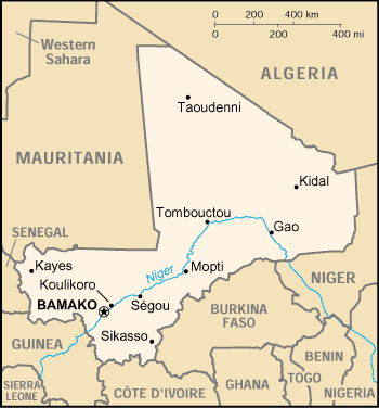
Fayil:Mali map.png
Appearance
Mali_map.png (pikisal 350 × 376, girman fayil: 11 KB, irin MIME: image/png)
Tarihin fayil
Ku latsa rana/lokaci ku ga fayil yadda yake a wannan lokaci
| Rana/Lokaci | Wadar sufa | Kusurwowi | Ma'aikaci | Bahasi | |
|---|---|---|---|---|---|
| na yanzu | 21:03, 3 ga Maris, 2005 |  | 350 × 376 (11 KB) | Alfio | CIA map of Mali |
Amfani da fayil
Wadannan 3 shafuka suna amfani wannan fayil:
Amfanin fayil a ko'ina
Wadannan sauran wikis suna amfani da fayil din anan
- Amfani a kan als.wikipedia.org
- Amfani a kan am.wikipedia.org
- Amfani a kan ast.wikipedia.org
- Amfani a kan ban.wikipedia.org
- Amfani a kan bjn.wikipedia.org
- Amfani a kan ca.wikipedia.org
- Amfani a kan ceb.wikipedia.org
- Amfani a kan da.wikipedia.org
- Amfani a kan de.wikivoyage.org
- Amfani a kan en.wikipedia.org
- Amfani a kan es.wikipedia.org
- Amfani a kan eu.wikipedia.org
- Amfani a kan fa.wikipedia.org
- Amfani a kan fi.wikipedia.org
- Amfani a kan fo.wikipedia.org
- Amfani a kan fr.wikipedia.org
- Amfani a kan he.wikipedia.org
- Amfani a kan hi.wiktionary.org
- Amfani a kan hu.wikipedia.org
- Amfani a kan hu.wiktionary.org
- Amfani a kan id.wikipedia.org
- Amfani a kan io.wikipedia.org
- Amfani a kan ja.wikipedia.org
- Amfani a kan jv.wikipedia.org
- Amfani a kan ko.wikipedia.org
- Amfani a kan mr.wikipedia.org
- Amfani a kan nds.wikipedia.org
- Amfani a kan nl.wikipedia.org
- Amfani a kan no.wikipedia.org
- Amfani a kan oc.wikipedia.org
- Amfani a kan pl.wikipedia.org
- Amfani a kan pt.wikipedia.org
- Amfani a kan ro.wikipedia.org
Duba ƙarin amfanin wannan fayil.


