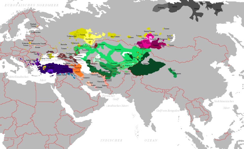
Fayil:Carte peuples turcs.png

Yanayin wannan rigayi gani: 800 × 490 pixels. Wasu yarjejeniyoyi: 320 × 196 pixels | 640 × 392 pixels | 1,024 × 628 pixels | 1,280 × 785 pixels | 1,690 × 1,036 pixels.
Hoton asali (pikisal 1,690 × 1,036, girman fayil: 99 KB, irin MIME: image/png)
Tarihin fayil
Ku latsa rana/lokaci ku ga fayil yadda yake a wannan lokaci
| Rana/Lokaci | Wadar sufa | Kusurwowi | Ma'aikaci | Bahasi | |
|---|---|---|---|---|---|
| na yanzu | 14:43, 20 ga Yuli, 2021 |  | 1,690 × 1,036 (99 KB) | MicBy67 | Reverted to version as of 17:50, 16 May 2020 (UTC) |
| 22:06, 16 Mayu 2020 |  | 1,690 × 1,036 (103 KB) | Satoshi Kondo | Reverted to version as of 02:07, 5 April 2020 (UTC) | |
| 17:50, 16 Mayu 2020 |  | 1,690 × 1,036 (99 KB) | SahinCcC | Reverted to version as of 23:11, 2 April 2020 (UTC) | |
| 02:07, 5 ga Afirilu, 2020 |  | 1,690 × 1,036 (103 KB) | Satoshi Kondo | Reverted to version as of 17:52, 26 November 2019 (UTC) ? | |
| 23:11, 2 ga Afirilu, 2020 |  | 1,690 × 1,036 (99 KB) | LenguaMapa | exclude fuyu kirgiz in Manchuria, mostly extinct today (not even 0,1% of total population). fixed distribution of anatolian turks | |
| 17:52, 26 Nuwamba, 2019 |  | 1,690 × 1,036 (103 KB) | Maphobbyist | Reverted to version as of 13:04, 1 May 2019 (UTC) | |
| 13:30, 20 Oktoba 2019 |  | 1,280 × 785 (362 KB) | LenguaMapa | Correction on Yakuts and Dolgans | |
| 22:36, 24 Satumba 2019 |  | 1,690 × 1,036 (100 KB) | LenguaMapa | minor corrections, more accurate now | |
| 13:04, 1 Mayu 2019 |  | 1,690 × 1,036 (103 KB) | Satoshi Kondo | Fuyu-Kirgisen, Hunan-Salaren, correction on Sakha-Yakuts distribution, Ürümqi(Xinjiang) | |
| 06:34, 30 ga Janairu, 2019 |  | 1,690 × 1,036 (126 KB) | MicBy67 | Reverted to version as of 15:43, 20 September 2018 (UTC). Bitte KEINEN EW führen. Es ist Usus, diese Gebiete in der Fachliteratur zu weißen oder mit schwächeren Farben als dünnbesiedelt zu kennzeichnen. |
Amfani da fayil
Wadannan shafi na amfani wannan fayil:
Amfanin fayil a ko'ina
Wadannan sauran wikis suna amfani da fayil din anan
- Amfani a kan af.wikipedia.org
- Amfani a kan azb.wikipedia.org
- Amfani a kan ca.wikipedia.org
- Amfani a kan cs.wikipedia.org
- Amfani a kan de.wikipedia.org
- Amfani a kan el.wikipedia.org
- Amfani a kan en.wikipedia.org
- Amfani a kan es.wikipedia.org
- Amfani a kan et.wikipedia.org
- Amfani a kan fa.wikipedia.org
- Amfani a kan frr.wikipedia.org
- Amfani a kan fy.wikipedia.org
- Amfani a kan gv.wikipedia.org
- Amfani a kan hak.wikipedia.org
- Amfani a kan hu.wikipedia.org
- Amfani a kan io.wikipedia.org
- Amfani a kan ja.wikipedia.org
- Amfani a kan ko.wikipedia.org
- Amfani a kan la.wikipedia.org
- Amfani a kan lfn.wikipedia.org
- Amfani a kan nl.wikipedia.org
- Amfani a kan nl.wiktionary.org
- Amfani a kan pa.wikipedia.org
- Amfani a kan pl.wikipedia.org
- Amfani a kan pnb.wikipedia.org
- Amfani a kan pt.wikipedia.org
- Amfani a kan ru.wikipedia.org
- Amfani a kan sco.wikipedia.org
- Amfani a kan sv.wikipedia.org
- Amfani a kan tr.wikipedia.org
- Amfani a kan uk.wikipedia.org
- Amfani a kan ur.wikipedia.org
- Amfani a kan vi.wikipedia.org


