
File:PIA03804 Artist's View of Odyssey Detecting Ice (Artist Concept).tiff

Hoton asali (pikisal 5,300 × 6,450, girman fayil: 68.93 MB, irin MIME: image/tiff)
Taƙaici
| Bayani |
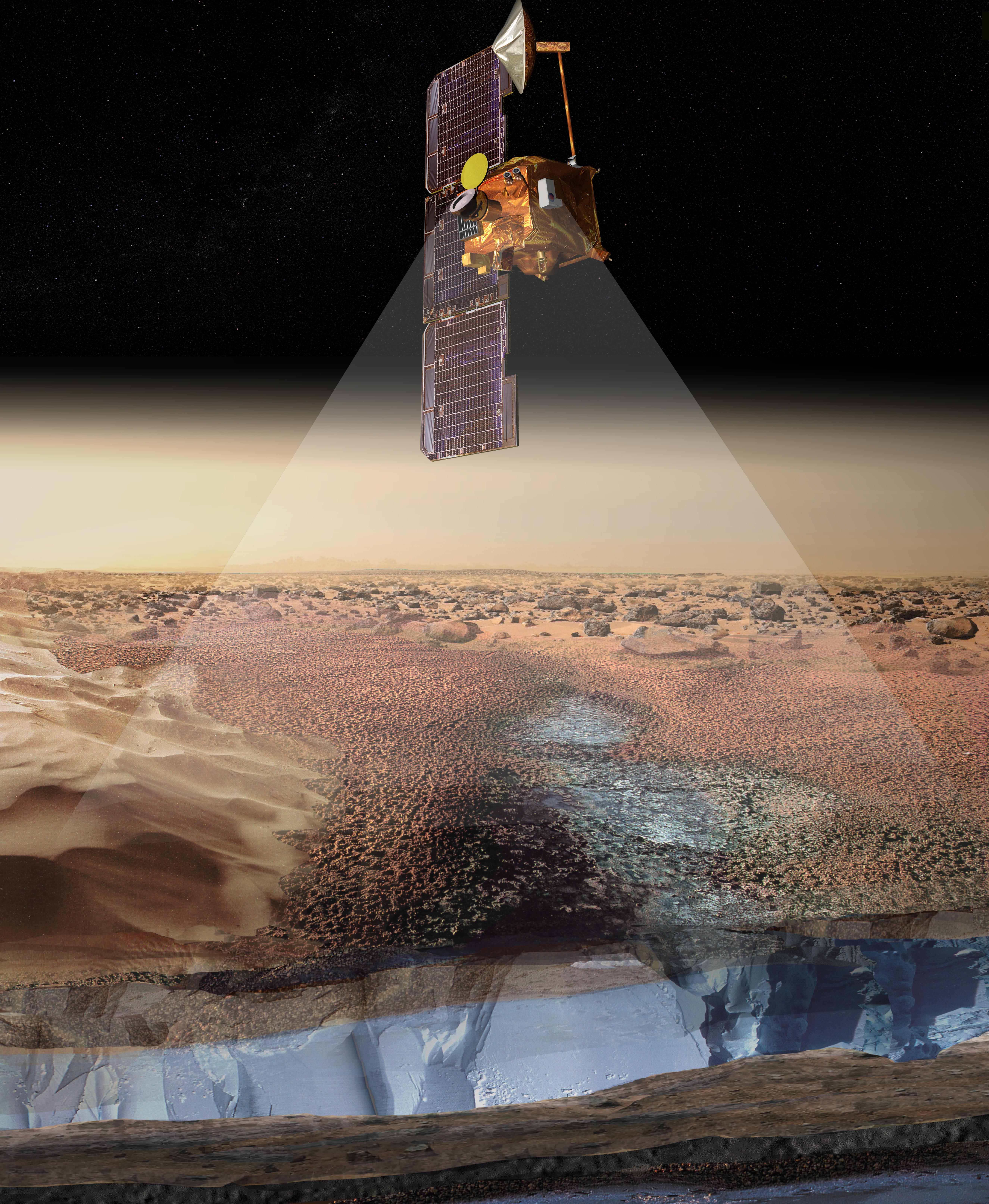
English: This artist's rendering portrays ice-rich layers in the soils of Mars being detected by instruments aboard NASA's 2001 Mars Odyssey spacecraft. Measurements by the gamma ray spectrometer suite of instruments indicate that the upper meter (three feet) of soil contains an ice-rich zone with an ice abundance of 20 to 50 percent by mass. The ice-rich areas surround the polar regions of Mars, down to latitudes of about 60 degrees, in both the north and the south. The instruments detect the signature of hydrogen, indicating water ice, to a depth of about one meter (three feet). It is not known whether or how deep the ice-rich zone continues below that depth. The view of the spacecraft in this artist's rendering is not to scale, as the observations are obtained from an orbital altitude of 400 kilometers (250 miles).
NASA's Jet Propulsion Laboratory manages the 2001 Mars Odyssey mission for NASA's Office of Space Science, Washington, D.C. Investigators at Arizona State University in Tempe, the University of Arizona in Tucson, and NASA's Johnson Space Center, Houston, operate the science instruments. The gamma-ray spectrometer was provided by the University of Arizona in collaboration with the Russian Aviation and Space Agency, which provided the high-energy neutron detector, and the Los Alamos National Laboratories, New Mexico, which provided the neutron spectrometer. Lockheed Martin Astronautics, Denver, is the prime contractor for the project, and developed and built the orbiter. Mission operations are conducted jointly from Lockheed Martin and from JPL, a division of the California Institute of Technology in Pasadena. |
| Rana | (published) |
| Masomi | Catalog page · Full-res (JPEG · TIFF) |
| Marubucin | NASA/JPL/University of Arizona/Los Alamos National Laboratories |
| Other versions |
|
.jpg)

This image or video was catalogued by Jet Propulsion Laboratory of the United States National Aeronautics and Space Administration (NASA) under Photo ID: PIA03804. This tag does not indicate the copyright status of the attached work. A normal copyright tag is still required. See Commons:Licensing. Other languages:
|
| This media is a product of the 2001 Mars Odyssey mission Credit and attribution belongs to the Gamma Ray Spectrometer (GRS) team, NASA/JPL/University of Arizona |
Lasisi
| This file is in the public domain in the United States because it was solely created by NASA. NASA copyright policy states that "NASA material is not protected by copyright unless noted". (See Template:PD-USGov, NASA copyright policy page or JPL Image Use Policy.) | ||
 |
Warnings:
|
Tarihin fayil
Ku latsa rana/lokaci ku ga fayil yadda yake a wannan lokaci
| Rana/Lokaci | Wadar sufa | Kusurwowi | Ma'aikaci | Bahasi | |
|---|---|---|---|---|---|
| na yanzu | 08:40, 3 ga Afirilu, 2018 |  | 5,300 × 6,450 (68.93 MB) | Jarnsax | c:User:Rillke/bigChunkedUpload.js: == {{int:filedesc}} == {{NASA Photojournal | catalog = PIA03804 | image = yes | mission = 2001 Mars Odyssey | instrument = Gamma Ray Spectrometer Suite | caption = {{en|This artist's rendering portrays ice-rich layers in the soils of Mars being detected by instruments aboard NASA's 2001 Mars Odyssey spacecraft. Measurements by the gamma ray spectrometer suite of instruments indicate that the upper meter (three feet) of soil c... |
Amfani da fayil
Wadannan shafi na amfani wannan fayil: