
File:WestAfrica1625.png
Babu wata babbar saƙa.
WestAfrica1625.png (pikisal 498 × 306, girman fayil: 31 KB, irin MIME: image/png)

|
This historical map image could be re-created using vector graphics as an SVG file. This has several advantages; see Commons:Media for cleanup for more information. If an SVG form of this image is available, please upload it and afterwards replace this template with
{{vector version available|new image name}}.
It is recommended to name the SVG file “WestAfrica1625.svg”—then the template Vector version available (or Vva) does not need the new image name parameter. |
Taƙaici
| Bayani |
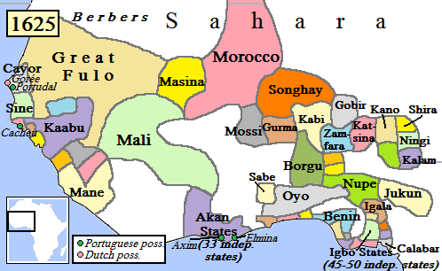
English: Map of West Africa, AD 1625.
(Partially based on Atlas of World History (2007) - Early modern Africa, map.) |
| Rana | |
| Masomi | Aikin na |
| Marubucin | Gabagool |
Lasisi
I, the copyright holder of this work, hereby publish it under the following license:
This file is licensed under the Creative Commons Attribution 3.0 Unported license.
- Za ka iya:
- a raba – dan kwafa, yadawa da aika aikin
- dan maimaita – dan daukar aikin
- A karkashin wannan sharuddan
- Jinginarwa – Dole ku bada jinjina da ta dace, samar da linki zuwa lasisin, da kuma bayyana ko kunyi sauyi. Zaku iya haka ta yadda ta dace, amma ba kowace hanya ba wanda zai nuna mai-lasisin yana goyon bayan ku ba ko goyon bayan amfanin da kuke yi ba.
Tarihin fayil
Ku latsa rana/lokaci ku ga fayil yadda yake a wannan lokaci
| Rana/Lokaci | Wadar sufa | Kusurwowi | Ma'aikaci | Bahasi | |
|---|---|---|---|---|---|
| na yanzu | 17:42, 5 Mayu 2010 | | 498 × 306 (31 KB) | Omar-Toons | Reverted to version as of 00:15, 16 June 2009 |
| 18:05, 20 ga Afirilu, 2010 |  | 497 × 306 (31 KB) | Bokpasa | Saadi dynasty and Tuaregs | |
| 00:15, 16 ga Yuni, 2009 |  | 498 × 306 (31 KB) | Gabagool | rm lines | |
| 19:57, 19 ga Afirilu, 2009 |  | 498 × 306 (32 KB) | Gabagool | {{Information |Description={{en|1=Map of West Africa, AD 1625. (Partially based on ''Atlas of World History'' (2007) - Early modern Africa, map.)}} |Source=Own work by uploader |Author=Gabagool |Date=2009-04-19 |Permission= |other_versi |
Amfani da fayil
Wadannan 5 shafuka suna amfani wannan fayil:
Amfanin fayil a ko'ina
Wadannan sauran wikis suna amfani da fayil din anan
- Amfani a kan af.wikipedia.org
- Amfani a kan als.wikipedia.org
- Amfani a kan ar.wikipedia.org
- Amfani a kan azb.wikipedia.org
- Amfani a kan bn.wikipedia.org
- Amfani a kan ca.wikipedia.org
- Amfani a kan da.wikipedia.org
- Amfani a kan de.wikipedia.org
- Amfani a kan en.wikipedia.org
- Mali Empire
- Songhai Empire
- Songhai people
- Sahelian kingdoms
- Oyo Empire
- History of West Africa
- Islamization of the Sudan region
- Kaabu
- Empire of Great Fulo
- Dendi (province)
- Legends of Africa
- Timeline of Nigerian history
- List of kingdoms in Africa throughout history
- Military history of the Mali Empire
- Nigerian traditional rulers
- User:OnBeyondZebrax/sandbox/African history
- User:Tisquesusa/sandbox9
- The Songhai
- Medieval and early modern Africa
- Amfani a kan en.wikibooks.org
Duba ƙarin amfanin wannan fayil.